The following notes about Solar radiation and Temperature inversion are based on standard reference books like the NCERTs for the benfit of aspirants. We hope you find these useful for a quick revision.
- Earth receives most of its energy in form of short wavelengths.
- Insolation is – incoming solar radiation.
- Earth is a geoid, resembling a sphere.
- Earth is farthest from the Sun – 4th July (Aphelion position)
- Earth is nearest to the sun on – 3rd January (Perihelion position)
- Factors responsible for variation in insolation during a day, season and a year:
- Rotation of Earth
- Angle of inclination of Sun’s rays.
- Length of day
- Transparency of atmosphere
- Configuration of land in terms of its aspect.
- Earth’s axis has a 66.5 degrees angle with plane of orbit round the sun leads to variation in insolation at different latitudes.
- Area covered by slant rays is more than vertical rays. Energy gets distributed and net energy received per unit area decrease. The slant rays of Solar radiation are absorbed, scattered & diffused more in deep atmosphere.
- The Solar radiation spectrum is beautifully explained by the following diagram.
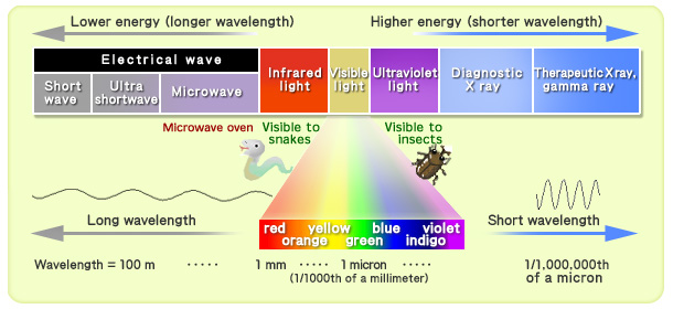
- Atmosphere is transparent to short wave solar radiation.
- In troposphere – The water vapour, ozone and gases absorb near infrared radiation.
- Small- suspended particles in troposphere scatter visible spectrum. It adds colour to the sky. Red colour of rising and setting sun is due to this. The blue colour of the sky are due to scattering of light within the atmosphere.
<< Read about the Emergency provisions in the Indian Constitution here>>
- Maximum insolation is received over the sub tropical deserts, where the cloudliness is the least.
- The Equator receives less than tropics, because it is at 90 degrees to the angle of insolation.
- The same latitude, insolation is more over continents than on oceans.
- Earth heated by Solar radiation then transmits the heat to atmosphere in Long wave form.
- Conduction – It heats the lower layers of atmosphere. When two bodies of unequal temperature come in contact with each other, there is flow of energy from warmer to cooler body. The air in contact with land gets heated slowly and the upper layer in contact also gets heated.
- Convection– It occurs only in troposphere. The air in contact with earth rises vertically on heating in form of current and further transmits the heat. Vertical heating of atmosphere is convection.
- Advection – The horizontal heat transfer through movement of air. In middle latitudes, most of diurnal variations in daily weather is by advection. Loo is also due to advection.
- Terrestrial radiation– The insolation received by the Earth is in form of short wave radiation. The Earth radiates energy to atmosphere in form of long wave radiation. The gases like Carbon-dioxide and other green house gases absorb this long wave radiation is trap the heat.
- The Atmosphere in turn radiates this heat in the space.
-
Heat budget of the Earth – Earth maintains its temperature. The amount of heat received in form of insolation equals the amount lost by Earth through terrestrial radiation.
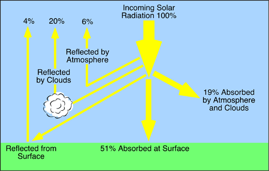
- Albedo of Earth – The reflected amount of radiation or insolation from clouds, snow, and ice-covered areas of earth is known as albedo.
- There is surplus of net radiation balance between 40 degrees North and South. While there is deficit in poles.
- Heat represents the molecular movement of particles comprising a substance. Temperature is measurement in degrees of how hot or cold a thing or place is.
- Factors controlling Temperature are:
- Latitude – Insolation received varies according to latitude.
- Altitude – Temperature decreases with increasing height. The rate of decrease of temperature with height is normal lapse rate. It is 6.5 degree Celsius for per 1000 meters.
- Distance from the Sea – The sea gets heated slowly, land heats fast. While sea loses heat slowly, land loses fast. Variation of temperature over sea is less than on land. Sea and land breeze influence on places near sea.
- Air-mass and ocean currents – Passage of air masses and currents affects the temperature of places where they pass.
- Local aspects– They also influence the local temperature.
- Isotherms are lines joining places having equal temperatures on map, are generally parallel to latitude.
- Highest range of temperature is more than 60 degrees Celsius over North-Eastern port of Eurasian continent, due to continentality.
<< Read about powers of UPSC here >>
Temperature Inversion :
- Normal lapse rate – Temperature decreases with increased elevation. It is 6.5 degrees Celsius per 1000m.
- When normal lapse rate is inverted, it is called inversion of temperature.
- Short duration but common in polar regions
- Long winter night with clear skies and still air is the ideal situation.
- Heat of day is radiated off during night. So by early morning, earth is cooler than the air above.
- Surface inversion promotes stability in lower layers of atmosphere. Smoke and dust particles collect beneath the inversion layer and spread horizontally filling lower strata of atmosphere.
- Dense fog in morning of winter season will last for few hours till the Sun comes up.
- Temperature Inversion in hills and mountains occur due to air Drainage. Cold air at hills and mountains, produced during night, flows under influence of gravity.
- It is heavy and dense, cold air acts like water and moves down slope to pile up deeply in pockets and valley bottoms with warm air above.
- Air drainage protects plants from frost damages.
<< Read about the History of Kushana empire in India here >>