Many times a question or two is randomly asked about some international or national boundary line as part of General Awareness in competitive exams. Recently, in January 2015 a question about 49th parallel was asked in an Insurance recruitment exam. For an unprepared candidate, the first thought that comes to mind would be -‘Where did such question come from?’. While the person who has read this article thoroughly and maybe revised once, would be delighted to see such easy-mark question in exam.
The topics like these, which talk of static GK make the difference between a serious aspirant and a layman trying his luck. The following list contains all the major and important lines and boundaries of countries around the world. Though the list is not exhaustive but be assured it will conveniently suffice for our purpose. I must point out here that the first few names are very important. You will find them frequently asked in General Awareness / knowledge section of exams.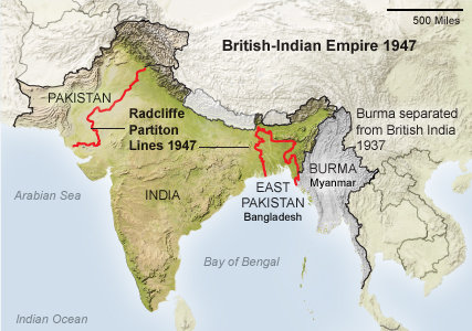
| Name of Boundary | Lies Between | Description |
| Radcliff Line | India and Pakistan | It became the international border between India and Pakistan on 17th August 1947 marking partition of India. It also included the present Bangladesh. |
| Durand Line | Pakistan and Afghanistan | This line demarcates was drawn up in 1893 by Sir Mortimer Durand in agreement with the Amir of Kabul. Afghanistan does not recognizes the Durand line. |
| MacMohan Line | India and China | It was drawn by Sir Henry McMohan demarcating the frontier between India and China. China does not recognise this line and violated it in 1962. |
| 49th Parallel | USA and Canada | 49th parallel is the circle of latitude located 49 degrees north of equator. It is the international boundary between USA and Canada according to Anglo-American convention of 1818 and Oregon Treaty of 1846. |
| 38th Parallel | North Korea and South Korea | It is circle of latitude 38 degrees north of equator. It formed border between North and South Korea prior to the Korean War. |
| 17th Parallel | North Vietnam and South Vietnam | It is a circle of latitude 17 degrees north of equator. It divided the erstwhile North and South Vietnam as demarcated by 1954 Geneva Accords. The 17th parallel became irrelevant after unification of Vietnam in 1976. |
| Hindenburg Line | Germany and Poland | The Germans went past this line during the World War I in 1917. It was built as th western front in WW I |
| Siegfried Line /Westwall | Germany and France (from German side) | It was built by Germany as extension of Hindenburg line during 1916-1917. |
| Maginot Line | Germany and France (from French side) | Its a 320 km line of fortification that was build by France along its border with Germany before World War II, in order to protect against German attack. |
| Mannerheim Line | Russia and Finland | It was a defensive fortification built by Finland to defend itself against |
| Oder-Neisse Line | Poland and Germany | It runs along the rivers Oder and Neisse. The Poland Conference in August 1945 after the World War II lead to its adoption. |
| 20th Parallel | Libya and Sudan | In Africa, the 20th parallel latitude located 20 degrees to the north to the equator, it marks the border between Libya and Sudan. |
| 22nd Parallel | Egypt and Sudan | The major part of Egypt and Sudan border follows the 22nd parallel. |
| 25th Parallel | Mauritania and Mali | The northernmost section of the Mauritania and Mali border is defined by the 25th parallel. |
| 31st Parallel | Iraq and Iran | A part of Iran-Iraq border is defined by the 31st parallel. In United States of America, the 31st parallel defines Mississippi and Louisiana. |
We hope this short compilation of important lines and boundaries of the world is helpful to candidates. This list will be useful to build GK for exams since you now know about all important boundaries related to India and the world. If we have left out any other noteworthy boundary name, or have mentioned any detail incorrect, please do let us know in the comment section below.