Drainage is the water flow through well defined channels. Drainage pattern is an outcome of geological time period, nature and structure of rocks, topography, slope, amount of water flowing and periodicity of the flow. The types of drainage patterns are:
- Dendritic – resembles branches of a tree, mainly north Indian Plains have rivers making this type of pattern.
- Radial – Flow in all directions from a hill, like Son and Narmada (rivers of Amarkantak Plateau)
- Trevellis– Primary tributaries flow parallel to each other and secondary tributaries join them at right angles.
- Centripetal – Rivers discharge water from all directions in a lake or depression.
Catchment Area: is that specific place or area from where river water is collected.
Drainage Basin: Area drained by a river and its tributaries, for large rivers, it is called a river basin.
Watershed: Small area separating one drainage basin from another, for small rivulets and rills, it is called watershed.
River basin and watersheds are marked by unity. What happens in one part affects another part or whole.
The rivers in India are classified on three different basis, let us look into each one of them.
I. On basis of discharge of water:
Through the Delhi Ridge, Aravalis and the Sahayadris, there is a separation of two systems of drainage in India:
- Arabian Sea Drainage: 23% of drainage falls into the Arabian Sea. Indus, Narmada, Tapi, Mahi and Periyar systems are included under this.
- Bay of Bengal Drainage: 77% of drainage in India falls into the Bay of Bengal. Ganga, Brahmaputra, Mahanadi, Krishna, and Kaveri river systems.
II. Based on Size of Watershed:
There are three categories of rivers in India on the basis of the size of watershed.
- Major River Basins: more than 20 thousand square km of the catchment area. 14 such basins – Ganga, Brahmaputra, Krishna, Tapi, Narmada, Mahi, Pennar, Sabarmati, Barak, Mahanadi, Godavari, Kaveri, Indus, Brahmani and Baitarni.
- Medium River Basins: Catchment area between 200-20,000 sq. km. 44 such basins – kalindi, Periyar, Meghna, etc.
- Minor River Basins: Catchment area less than 2000 sq. km. Rivers in areas of low rainfall.
III. Based on mode of origin, nature and Characteristics:
It is the most accepted classification, based on the origin, nature and characteristics, there are two types of drainage system with various rivers in India.
1. Himalayan Drainage
This drainage is perennial river system, fed by snow and precipitation. Makes deep gorges, V-shaped valleys, rapids and waterfalls. In plains, they form flat valleys, ox-bow lakes, flood plains, braided channels, deltas near the river mouth.
A) Indus River System:
It is one of the largest river basins of world. Western-most of Himalayan rivers in India. Origin is from glaciar near Bokhar Chu in Tibet region in Kailash Mountain Range. The Indus river moves between Zaskar and Ladakh ranges, passes through Ladakh and Baltistan. It cuts Ladakh range, forming a gorge near Gilgit in Jammu and Kashmir.It enters Pakistan near Chillar in dardistan region.
The Tributaries of Indus are: Shyok, Gilgit, Zaskar, Hunza, Nubra, Shigar, Gasting, Dras. Near hills of Attock, receives Kabul, Khurran, Tochi, Gomal, Viboa, Sangar on right bank. Above Mithankot, it receives “Panjnad” – 5 rivers of Punjab: Satluj, Beas, Ravi, Chenab, Jhelum. Discharge into Arabian Sea, east of Karachi.
In India, Indus only flows through Leh district.
Jhelum: Arises from spring at Verinag, at foot of Pir Panjal(SE Kashmir). It flows through Srinagar and Wular Lake. It then enters Pakistan through deep narrow gorge. It then joins Chenab near Jhang in Pakistan.
Chenab: It is largest tributary of Indus. Two streams Chandra and Bhaga join to form Chenab near Keylong in Himachal Pradesh.
Ravi: It origins near west of Rohtang pass and flows through Chambal valley from Kullu hills. It then drains area between South-eastern Pir Panjal and Dhauladhar ranges. Ravi then joins Chenab in Pakistan at Sarai Sindhu.
Beas: It origins near Beas kund near Rohtang pass. It passes through Kullu valley, gorges at Kati and Largi in Dhaoladhar range. It eners Punjab then, meets Satluj at Harike.
Satluj: It originates in Rakas lake near Mansarovar in Tibet, there it is called Langchen Khambab. Satluj flows parallel to Indus for 400 km, enters India at gorge in Rupar. through Shipki La it enters Punjab plains. It is a Bhakra Nangal project feeder. Satluj is an Antecendent river.
B) Ganga River System:
It originates Gangotri glaciar near Gaumukh in Uttarakashi in Uttarakhand. There it is called Bhagirathi.
Alaknanda origin- Satopanth glaciar above Badrinath formed by combination of Dhauli and Vishnu Ganga at Joshimath(Vishnu Prayag). At Karna Prayag, Pindar joins Alaknanda. At Rudra Prayag, Mandakini or Kali ganga meets Alaknanda. At Devprayag, Alaknanda meets with Bhagirathi to form Ganga.
Ganga enters the plains at Haridwar and moves in the direction of South then Southeast then East. Thereafter, it splits into Bhagirathi and the Hugli. Ganga discharges in Bay of Bengal near Sagar Island.
Right Bank tributaries: Yamuna and Son.
Left Bank tributaries: Ramaganga, Gomati, Ghagghara, Gandak, Kosi, Mahananda.
Yamuna: It is the longest and westernmost tributary. It originates from Yamunotri glaciaron Bunderpunch range. Joins Ganga at Prayag at Allahabad. Its own tributaries are Chambal, Sind, Betwa, Ken on right. Hindan, Rind, Sengar, Varuna from left bank.
Chambal: It originates at Mhow in Malwa plateau of MP. Flows through gorge to Kota (Gandhisagar dam) to Bundi, Sawai Madhopur, Dholpur and joins Yamuna. Chambal ravines are badland topography.
Gandak: Kaligandak and Trishulganga combine to form Gandak. It originates from Nepal Himalayas between Dhaulagiri and Mt. Everest. It drains central Nepal, enters ganga plain in Champaran district of Bihar. Gandak joins Ganga at Sonpur near Patna.
Ghaghara: It originates from Mapchachuno glaciar in transhimalayas and comes out from a deep gorge at Shishapani. At Chhapra it joins Ganga.
Kosi: It is an antecendent river which originates from North of Mt. Everest inTibet. Kosi joins Ganga at Bhagalpur.
Ramganga: It originates from Garhwal Hills and joins Ganga near Kannauj.
Damodar: It originates at Chotanagpur Plateau and flows through rift valley. Damodar joins Hugli. It is also known as “Sorrow of Bengal” earlier, now it is a boon to WB due to the Damodar Valley Corporation Multipurpose Project.
Mahananda: It originates from Darjiling hills and joins Ganga as last left bank tributary in West Bengal.
Son: It is a large south bank tributary which has its origin at Amarkantak plateau. Son joins Ganga at Arrah, west of Patna.
C) Brahmaputra River System:
It originates at Chemayungdung glaciar in Kailash range near Mansarovar lake. It initially flows eastwards longitudinally as Tsangpo. Then it emerges as turbulant river, forms deep gorge at Namcha Barwa in Central Himalayas. Withg the name Dihang(Siang) it enters India at Sadiya town in Arunachal Pradesh and flows south to meet Dibang(Sikang) and Lohit to form Brahmaputra.
Left Bank tributaries: Burhi Dihing, Dhansari
Right Bank tributaries: Subansiri(origin in Tibet, antecendent river), Kameng, Manas, sankosh.
Brahmaputra enters Bangladesh near Dhubri and flows south. Thereafter Testa joins on its right bank and goes by the name Yamuna. and falls into Bay of Bengal after meeting Padma.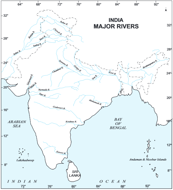
2. Peninsular Drainage System
The Peninsular rivers of India are older than the Himalayan rivers. They are broad, largely graded shallow valleys and mature rivers and have a fixed course, absence of meanders, non-perennial water flow.
The water divide occurs at Western Ghats along western coast. Except Narmada and Tapi, most rivers flow from west to east into Bay of Bengal.
<< Reada about National income accounting here>>
A) Narmada:
It originates in western flank of Amarkantak plateau and flows in rift valley between satpura in south and Vindhyan ranges in north. Narmada forms a gorge in marble rocks and Dhunadhar waterfall near Jabalpur. Sardar Sarovar Project has been built in Narmada. It meets Arabian Sea south of Bharuch forming a 27 km long estuary.
B) Tapi:
It originates at Multai in betul in Madhya Pradesh and drains Maharashtra, MP and Gujarat. Tapi flows in rift valley does not have much alluvial deposits.
C) Luni:
It is ephemeral and largest in Rajasthan in west of Aravali. Luni originates near Pushkar in two branches of Saraswati and Sabarmati. Join each other at Govindgarh and from here it is called Luni and drains into Rann of Kuchchh.
D) Mahanadi:
It originates from Sihawa in Raipur, Chattisgarh through Orissa into Bay of Bengal. It covers MP, Chhattisgarh and Orissa.
E) Godavari/ Dakshin Ganga:
Godavari is the largest Peninsular river system. It originates fron Nasik, Maharashtra. It drains into Bay of Bengal. Godavari runs through Maharashtra, MP, Chhattisgarh, Orissa, Andhra Pradesh. In lower reaches to south of Polavaram, heavy floods forms gorge.
F) Krishna:
It is a second largest east flowing peninsular river. Krishna originates from Mahabaleshwar in Sahayadri. Its tributaries are Koyna, Tungabhadra and Bhima. It drains into Maharashtra, Karnataka, Andhra Pradesh.
G) Kaveri:
It origins from Brahmagiri hills of Kogadu district in Karnataka. Kaveri receives water through southwest monsoon and northeast monsoon also. So less fluctuations in water levels than other peninsular rivers. Drains Kerala, Karnataka and Tamil Nadu. Kabini, Bhavani, Amaravati are its tributaries.
<< Read about list of multipurpose river projects in India here>>
<< Read about Mahayana and Hinayana Buddhism here>>