All the water on Earth including the oceans, seas, lakes, lagoons, rivers, ice and glaciers, water in atmosphere is called hydrosphere. There is more water in the Southern hemisphere as compared to Northern hemisphere.
Hydrological Cycle – Circulation of water within the Earth’s hydrosphere in different forms is known as Hydrological cycle.
The water resource in Oceans is maximum at 71% of the planetary water.
Availability of Water on surface of Earth :
Oceans > Icecaps > Glaciers & underground water > Lakes > Soil moisture > Atmosphere > Streams & rivers > Biosphere.
Water resource in Oceans: Pacific ocean > Atlantic ocean > Indian ocean > Arctic Ocean.
Processes of water cycle and its components :
- Water storage in oceans – Evaporation, evapo-transpiration, Sublimation
- Water in the atmosphere – Condensation, precipitation
- Water storage in ice caps and snow – Snowmelt runoff to streams.
- Surface runoff – stream flow freshwater storage infiltration
- Groundwater storage – Groundwater discharge springs
<< Read about Fundamental Duties under Indian Constitution here>>
Relief of Ocean floor:
Since the oceans are confined to great depressions of earth’s outer layer. The major portions of ocean floor is found between 3-6 km below the sea level. These ocean floors are rugged with the world’s deepest trenches, largest mountain ranges and the largest plains. All these features are formed by the tectonic, volcanic, and depositional processes.
Division of the Ocean Floor:
I. Continental Shelf:
- Extended margins of each continent occupy shallow seas and gulf. It breaks at steep slope known as shelf break.
- It very narrow at coast of Chile, west coast of Sumatra.
- Largest Shelf is at Siberian Shelf in Arctic Ocean at 1500 km in width.
- Massive deposits over time by the continental shelves become source of fossil fuels.
II. Continental Slope:
- It connects the continental shelf and the ocean basins.
- The gradient of the slope region changes between 2-5 degrees.
- This slope boundary indicates the end of the continents, so canyons and trenches are observed.
III. Deep Sea Plains:
- Gently sloping areas of basin covered by clay and silt.
- These are the smoothest and flattest regions of the Earth.
- These are gently sloping areas of the ocean basins.
IV. Oceanic Deep or Trenches:
- These are the deepest parts of the oceans.
- Oceanic trenches occur at bases of continental slopes , along island areas.
- They are associated with active volcanic and Earthquake activity, this makes them significant for Plate movement studies.
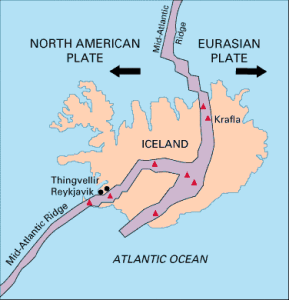
V. Mid- Oceanic Ridges:
- They consist of 2 mountain chains that are separated by a large depression.
- These ranges can have peaks reaching above the ocean floor as well.
- For instance, Iceland is a part of the Mid- Atlantic Ridge.
VI. Seamount:
- These are volcanic in origin.
- Mountain with pointed summits, do not reach the surface of the ocean.
- Emperor Seamount is an extension of Hawaiian islands in the Pacific Ocean.
VII. Submarine Canyons:
- Deep valleys cutting across Continental Shelf, often extending from mouth of large rivers.
- The Hudson Canyon is an example.
VIII. Guyots:
- These are flat topped seamount.
- An show signs of subsidence to become submerged.
IX. Atoll
- Atolls are low islands in tropical oceans having coral reefs surrounding a central depression.
- They may be part of a lagoon.
- They are located in tropical oceans.
Factors affecting temperature distribution of Ocean water:
A vital property of the water resource in oceans is its temperature. The variation in temperature cause various form of activity in the oceans. Let us first look into the factors that affect this temperature distribution.
- Latitude: Temperature decreases from equator to poles because of insolation decreases.
- Unequal distribution of land and water: Oceans in Northern hemisphere receive more heat due to their contact with larger extent of land than the oceans in Southern hemisphere.
- Prevailing Wind: Wind from land to oceans warm the surface water away from the coast. This results in longitudinal variations in temperature. Whereas, the onshore winds pile up warm water close to the coast, raising the temperature.
- Ocean Currents: Warm currents raise temperature while cold currents decrease the temperature in cold and warm areas respectively. Foe instance- The Gulf Stream(warm current) raises the temperature near Eastern coast of North America and West coast of Europe.
<< Read about the process of Government budgeting here >>
The enclosed seas at low latitudes see a higher temperature than open seas, whereas the enclosed seas in high latitudes experience lower temperature than open seas.
Distribution of Temperature:
The temperature-depth profile for water in ocean shows how temperature decreases with depth. It shows a boundary region between the surface waters of the ocean and the deeper layers.
Thermocline– The boundary line shown by the boundary region between surface waters of ocean from where there is a rapid decrease of temperature. 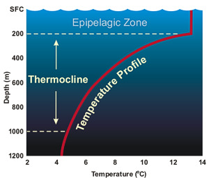
90% of total volume of water is found below the thermocline in deep ocean. 100-400 m below the sea surface.
The temperature structure of ocean is divided into three layers:
Ist layer : The top layer of warm oceanic water is 500 m thick with 20-30 degrees of temperature. Within tropical region, this layer is present throughout the year, but in middle latitudes it is found only in summer season.
IInd layer : The thermocline layer shows rapid decrease in temperature with increasing depth. It is 500-1000m thick.
IIIrd layer: It is very cold and extends upto deep ocean floor.
The average temperature of ocean surface water is 27 degrees Celsius.
The highest temperature is recorded slightly above the equator because of unequal distribution of land and water in the northern and southern hemisphere.
Maximum temperatures of the ocean is always at the surface because it directly receives heat from the Sun and the heat is transmitted to the lower sections of the oceans by the process of convection.
<< Read the list of Jnanpith award winners till date here>>


